
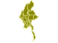
Myanmar State and Region Boundaries with Sub-regions MIMU v9.4
This dataset is part of the
Myanmar Data Grid


Downloads
Related Showcases
Myanmar State and...
Polygons of Myanmar State, Region and Union territory boundaries (Admin1) with Sub-regions, based on the latest MIMU Pcode version 9.4...
1 Dataset
-
hdx_bot_geopreview updated the dataset Myanmar State and Region Boundaries with Sub-regions MIMU v9.4
1 month ago -
1 month ago -
hdx_bot_scrapers updated the dataset Myanmar State and Region Boundaries with Sub-regions MIMU v9.4
1 month ago -
5 months ago -
5 months ago -
5 months ago -
6 months ago
-
Myanmar State and Region Boundaries with Sub-regions MIMU v9.4 shapefileSHP
Modified: 18 June 2023
-
Myanmar State and Region Boundaries with Sub-regions MIMU v9.4 geojsonGeoJSON
Modified: 18 June 2023
 Download
| Source | Myanmar Information Management Unit (MIMU) |
|---|---|
| Contributor | Myanmar Information Management Unit (MIMU) |
| Time Period of the Dataset [?] | June 18, 2023-June 18, 2023 ... More |
| Modified [?] | 18 June 2023 |
| Dataset Added on HDX [?] | 12 March 2024 Less |
| Expected Update Frequency | As needed |
| Location | |
| Visibility |
Public
|
| License | Other : |
| Methodology | |
| Caveats / Comments | |
| Tags | |
| File Format |